
RYM-C2004 - Rakennetun ympäristön paikkatiedot, Luento-opetus, 13.9.2021-27.10.2021
This course space end date is set to 27.10.2021 Search Courses: RYM-C2004
Topic outline
-
Rakennetun ympäristön paikkatiedot RYM-C2004 (GIS in built environment 2021)
Welcome to the course. In fall 2021 the course will be offered mainly in English. The course will be mainly online. However, there will be two GIS clinics held on-site where students can join online or in person if they prefer.
The first lecture will be on 13.09.2021 at 10:15-13:45.Responsible teacher: Kamyar Hasanzadeh, kamyar.hasanzadeh@aalto.fi
Guest lecturers: Marketta Kyttä, Anna Kajosaari, Samira Ramezani, Petri Kangassalo
Exercise: Kamyar Hasanzadeh, Anna Kajosaari (etunimi.sukunimi@aalto.fi)Timetable
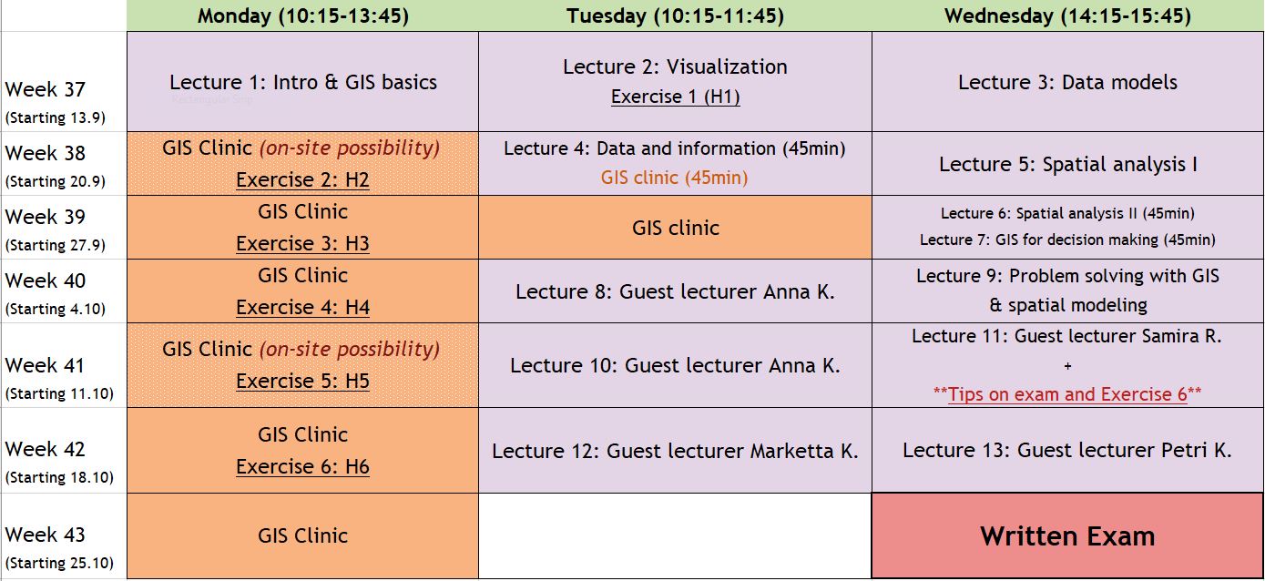 * There can be minor changes to the timetable during the course
-
Here in this forum you can discuss about all kinds of things related to the course and/or post your questions
-
Zoom information Page
-
Course implementation and forms of work:
Lectures:
All the lectures will be held online in Fall 2021. We will use Zoom platform for all lectures and exercise sessions. You can join the session using this link: https://aalto.zoom.us/j/62398731436
All lectures will be recorded and shared on my courses for those who cannot attend the live sessions. The contents will not and should not be shared outside the course.
Attending the lectures or exercise sessions is not compulsory but of course recommended.
Exercises:
Exercises will be arranged mostly online (GIS clinics). Exercise sessions will be organized in Zoom platform. You can access the sessions using the same link as lectures (here). There will be a few on-site exercise sessions that a limited number students can attend if they wish to. During the on-site exercise session the instructor will also be available online.
The exercises are always published two days before the actual date for them on the calendar. You can already start working on them and show up for the GIS clinics if you have problems or questions. During the GIS clinics we will together go through part of the exercise. But the main goal is that during these exercise hours, the instructor is available to help you with your questions related to the exercises. If you need help with the exercise, book a call time using this form. The instructor will call you in zoom.
How do I do the exercise remotely?
A detailed instruction will be published with the exercise. Following the instructions you should be able to successfully complete the exercise. Video guidance may be also provided for some of the exercises.
This fall we will use the GIS software QGIS. This is a free software and you can download it for free from www.qgis.org/en/site/forusers/download.html . The software is available for Windows, as well as macOS and Linux.
You can also access the software remotely. read more here: https://www.aalto.fi/en/news/remote-access-to-windows-classroom-computers-during-covid-19-situation
Windows 10 - A046
Windows 10 - A046A
Windows 10 - Maari C
Windows 10 - Maari EIf you do not have access to a personal computer you can find QGIS in the following classrooms. (Given the uncertatinties resulting from pandemic situation the availability of classrooms may very a anytime)
- Maari-C-D, Maari-E (Maarintalo)
- U257, U344, U351, Y344 (Otakaari 1)
- A046 ja A046a (Otakaari 1, A-osaston kellarikerros)
Course evaluation criteria:
Preliminary assignment: There is a compulsory preliminary task that you need to complete before the course starts. You will not be graded for this but you need to complete it in order to enroll in the course.
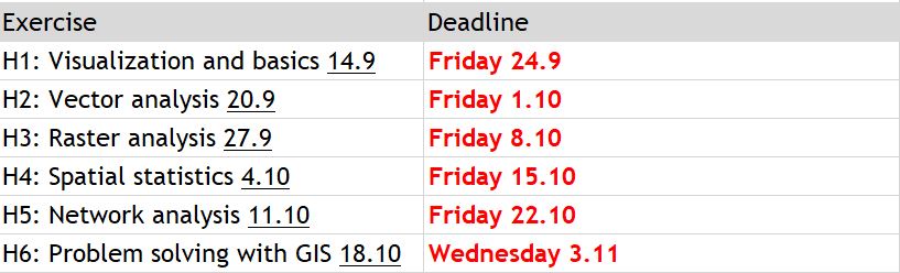
Exercises: There are 6 exercises that make up 50% of your total grade in this course. Weights for exercises are as follows:
H1: Visualization and basics (7%)
H2: Vector analysis (7%)
H3: Raster analysis (7%)
H4: Spatial statistics (7%)
H5: Network analysis (7%)
H6: Problem solving with GIS (15%)
Note: All exercises are individual tasks and cannot be done in groups.
Written exam: The written exam will make up 50% of your overall grade in the course. Exam will be held on: 27.10.2021 (13-16) – (Re-exam: 22.12.2021)
Lecture assignments: There will be short online assignments following some of the lectures. It is not compulsory to pass these quizzes. A full score on these assignments will have positive effect on your overall score.
Final grade: The average of scores as stated above. Lecture assignments can have positive effect on the overall grade.
-
Luentotehtävä 2 - Visualisointi - the good, the bad, and the ugly! Quiz